Timor Leste – Four Mountains
Ramelau, Mundo Perdido, Matebean Mane and Manucoco
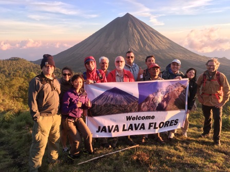
Basics: Java Lava climbed four mountains in Timor Leste in June 2018. The trip took 14 days mainly due to travel on notoriously bad roads as well as boat to Pulau Atauro. July through October is the driest period when clouds on the mountains are least. All mountains can be climbed in one day. Longer treks are possible, even a cross-island trek of eight days.

School girls at Baguia who spoke excellent English
Outside the main towns, Dili and Bacau, most people speak some Indonesian learnt during the Indonesian occupation and now from TV. English and Portuguese are being taught in some schools. Tetum is the local lingua franca. Accommodation in guesthouses is basic but quite adequate with meals extra. 4WD station wagon is the most reliable and comfortable means of travel.
Arrangements for vehicles and accommodation were made through a local travel agent, Eco-Discovery, +670 3322454, +670 77269829, attn: Manny. The itinerary included places of natural beauty/scenery/agriculture including Arabica coffee plantations and historical/cultural sites.
Go to http://www.gunungbagging.com/ for a full description of Gn Ramelau. Descriptions of Gns Mundo Perdido, Matebean and Manucoco may be posted to GunungBagging in due course.
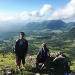
Gunung Ramelau (2,963 m)
Gn Ramelau, also known as Foho Tatamailau, is the highest peak in Timor Leste and is of deep religious and cultural significance. Adorned with a statue of the Virgin Mary at its peak, Ramelau is the site of an annual religious pilgrimage. The trip from Dili to Hatobuilico (v. 1,920 m), a beautiful hillside
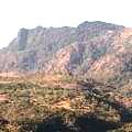
Gn Mutis in West Timor
town surrounded by high mountains, takes 4-5 hours along 100 kms of rough roads. Alecrim guesthouse is currently the only accommodation. The climb is easy up formed steps initially then a well-worn path – about v. 1,000 m taking 3+ hours. Start at 03:30, drive several kms to the trailhead and be at the summit for sunrise. Excellent views. Guides are not necessary.
Gunung Mundo Perdido (1,763 m)
Trailhead – Mundo Perdido
This mountain offers a lovely day trek but reaching its true summit would be difficult. Mundo Perdido means ‘Lost World’ from the early Portuguese who first encountered the mountain covered in mist. Mundo Perdido is an isolated mountain massif and a Protected Area with the largest remaining closed-canopy of montane forest in Timor. It is designated as an ‘Interesting Bird Area’ and is an important site for conservation of orchids.
Emerging onto cow pastures
The trailhead is just before Ossu on the seriously degraded Baucau-Viqueque road. Bacau-Ossu is about 3+ hrs. Accommodation is available just south of Ossu before Loihuno. Guesthouse Loihuno describes itself as an ‘eco-lodge’. Adriano operates a more basic guesthouse nearby. A cave in a nearby mountain was a guerrilla hideout during the Indonesian occupation and is now a memorial for those killed during the resistance.
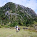
The trailhead is on the saddle several kilometres north of Ossu (about v. 950 m). A local guide is recommended to find the trailhead, to navigate in the event of cloud, and if descending via the ‘longer route’ (below). The trail climbs up the right-hand side of an enormous karst limestone outcrop through broken rock and forest – but nothing difficult. Hint: follow the cow pads – they always find the easiest route up a mountain! After about 1:30 hrs and at about 1,300 m, the trail emerges onto open, steep cow pastures where Bali cattle and buffalo graze. Look back to the east for an amazing profile of Gunung Matebean. There are spectacular views towards the south coast.
True summit of Mundo Perdido – in cloud
The true summit of Mundo Perdido lies some distance beyond to the east through dense forest. The peak appears to be a very steep, with a rugged climb up karst limestone rocks. Upon enquiring about climbing the summit, our guides simply informed, ‘tidak bisa’ (not possible). Further exploration required!
The descent via the ‘longer route’ is easy, through the cow pastures then light forest (muddy in places
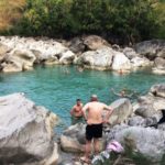
from springs on the mountain), village gardens and back to the trailhead. The round-trek took some 6-7 hours. Finish the day with a swim in a river across the road from Adriano’s villa. A very enjoyable day and highly recommended!
Gunung Matebean Mane (2,372 m)
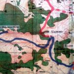
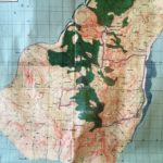
Blue line shows Matebean trail
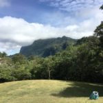
The Matebean (also spelt ‘Matebian’) massif is one of the wildest and most rugged mountain ranges on the island of Timor, and has a fascinating yet bloody recent history. It has two summits – Mane (the ‘male’ – true summit) and Feto (the ‘female’ – ? m, further to the north). Matebean mean ‘Spirits of the Dead’ (mate – ‘death’, bean – ‘spirit’). Folklore holds that the souls of the good go to Matebean. During the Indonesian occupation from 1975, the mountain was a guerrilla hideout where many people sought refuge, and died, in caves on the mountain.
Escola do Reino de Haudere
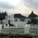
Pousada Baguia
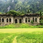
Matebean is reached from Bacau via Laga (about 18 km) on the north coast and then south-east to Baguia (another 43 km). An impressive ruined building, in classic Portuguese style, ‘Escola do Reino de Haudere’, lies on the right hand side of the road (‘the old school road’) about 2-3 km before Baguia (v. about 450 m). This was a Portuguese school built in the early 1900s but destroyed in the 1940s during the Japanese occupation. Guest House Rabilai (+670 77376137, 76202770) at Baguia offers basic but adequate accommodation and meals. Pousada Baguia, a hilltop Portuguese outpost, has been renovated and now offers a higher-class of accommodation.
Profile of Matebean from Mundo Perdido
The trailhead is at Uaiboro (pronounced ‘whey-bore-oh’) and follows the blue line on the topographical map (photo above). The road from Baguia to Uaiboro is via Ossohuna (v. about 800 m). The section, Baguia – Ossohuna (about 7 kms), is passable by 4WD vehicles and motorbikes. The road to Uaiboro branches off to the right just before Ossohuna. Even 4WDs have difficulty with this section. It’s more enjoyable to walk – about 2 km, v. 250 m, about 30 mins.
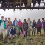
At Uaiboro (v. about 1,120 m), register at the house of the community leader Martino de Silva and pay an ‘entrance fee’ of $20 for the group. The trail is crisscrossed by numerous tracks leading to gardens and cloud cover can present a challenge. A guide from Uaiboro is essential, but might refuse if cloud cover is too heavy or rain is imminent.
 The trail is not too demanding traversing the steep slopes diagonally making for a more gently ascent. It passes initially through gardens and cow pastures on steep slopes then through Eucalyptus groves at about 1,900 m with thick grasses below. Interesting fluted, karst limestone outcrops are passed on the way.
Java Lava in the Capella
After about 3:30 hrs from Uaiboro and at about 2,100 m, there is a small, dilapidated Capella (chapel) where the villagers pray each October (and in which cattle take shelter turning the ground into a quagmire of mud and manure). The trail to the summit (another 220 m vertical, about one hr) now becomes much steeper with some big rocks to scramble up. The ascent from Uaiboro to the summit, about 4.5 km, took about 4.5 hrs.
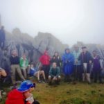
Climbers below the summit
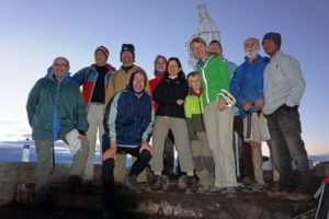
The summit is jumble of large, monolithic karst limestone rocks. A small, elegant stature of Christ is on the summit. On this occasion, given the heavy cloud, we missed the spectacular views across the island – from the north to the south coasts. “The views are truly stunning with a feeling of being on the top of the world. On a clear day Tasi Feto (feto female) = northern sea, and Tasi Mane (mane male rough = southern sea) are clearly visible.” (Trekking East Timor).
The descent by the same route normally takes about 3+ hrs. But if there is cloud/rain, the limestone rocks are extremely slippery, which slows the descent very considerably.
Gunung Manucoco (995 m)
Gn Manucoco is at the southern tip of Atauro
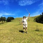
Manucoco (spelt ‘Manukoko’ in Indonesian) is the highest peak on the island of Atauro (pronounced ‘ata-uro’) and is located on its southern tip. Atauro is about 16 kms off the north coast from Dili.
The island is about 25 kms long, 9 kms wide and 140 sq km, with a population of about 9,000 who speak three local languages. The lingua franca of the island is Indonesian and Tetum. The people in the north are Catholic and those in the south Protestant. Traditional beliefs and practices are still very much a part of daily life. Historically, Atauro was used by both the Portuguese and Indonesians as a place of exile. The Portuguese fled here from Dili for safety in 1975.
The Government is promoting Atauro as a tourist destination: “Enjoy the peace and tranquillity of a naturally beautiful, simple and unspoilt part of the world. Snorkel in clear water and see an amazing pristine underwater world of incredible diversity. Go scuba diving on some of the best and untouched coral reefs in the world. Climb Manucoco.” Atauro was a delightful conclusion to our climbing trip with excellent snorkelling and relaxation in a beautiful beach setting.
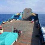
Laju Laju landing craft – Pulau Atauro crossing
For information on boats to/from Atauro Island check http://www.barrysplaceatauro.com/getting-here.html. The Dragon Star fast boat takes just over an hour but is not a pleasant experience – doesn’t handle the waves well and passengers are confined inside without fresh air and views. The landing barge, Laju Laju, takes three hours but is much more enjoyable sitting on deck with the sea breezes and views of Atauro and Timor. Barry’s Place, Beloi, is easy going and includes everything that a traveller needs. Barry can assist with guides and transport to the trailhead.
 Gunung Manucoco is a wonderful trek with views across the island and its idyllic coastline. The mountains are mostly limestone with some ancient volcanic rock formations. The trailhead is some four km south of Beloi on a road leading inland to new military barracks. A guide is needed to locate the trailhead and navigate the numerous tracks that crisscross the lower reaches connecting plantations, both on the ascent and descent.
Starting at a low altitude (about 100 m), the trek is a hot and sweaty. Allow 3 hours up and 2 hours down if returning by the same way. An alternative is to traverse over the ridge to the village of Anartuto from where it’s a 3-hour trudge back to the trailhead mostly on a dirt road.
Summit -Manucoco
The trail is in three sections. Initially, the trek is dry and hot through small farms and coconut and pineapple plantations. The middle section is easier and more enjoyable with tall grass and scattered trees. The path becomes narrow and winds its way up some steep slopes. The final, highest section is through lush forest and is much cooler. The trail emerges at a junction on a saddle where a spur trail leads to the summit while the main trail continues on to Anartuto Village. The last section, to the summit, narrows to some five metres. There is a survey mark at the summit and delightful views.
The return via the village of Anartuto is an easier trail, descending slowly through grasses, Eucalypts and plantations. Manucoco is a highly recommended trek on a visit to the beautiful Island of Atauro, Timor Leste.